Geofencing has become a popular term thrown around by those in the unmanned aircraft industry, as well as the slightly less informed like politicians and the media, as an approach to preventing “careless” drone flying near certain areas on the ground.
Well what is geofencing?
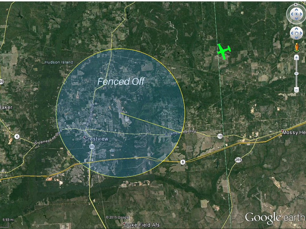
Geofencing is simply the creation of virtual fences around areas or points of interest to keep drones away. The drone will need a reliable navigation system (i.e. GPS) and autopilot software to create and interact with a fence. For example, in the figure below, I have added a common five mile “no-fly-zone” around the Crestview airport (KCEW). The aircraft’s autopilot could store the position (latitude and longitude) of the airport, as well as other nearby airports. As the drone flies, the autopilot continually computes the distance between the drone and the airport. When it reaches five miles, the autopilot must respond with a maneuver and/or notify the pilot to do something. If the drone was already in the no-fly-zone, then the control system may prevent takeoff or flying above a specific altitude.
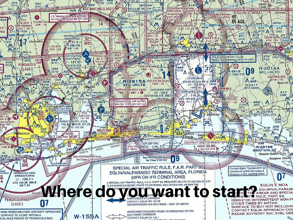
Geofencing an area of interest can be substantially more complicated. In these cases, the drone’s autopilot is calculating when it will cross a boundary stored as a collection of latitude and longitude points. And unfortunately, many areas are not simple geometric shapes and straight lines. Their boundaries follow rivers and roads or were developed long ago without any forethought to them being used in drone autopilots. When you run into airspace like that of Northwest Florida, you may actually start to develop some pity for the poor drone (and the pilot). What happens when it gets itself into a corner between an airport and restricted airspace? Does it bounce around no-fly zones like a pin ball machine?
Simple geofencing that is controlled by the pilot is a good feature for a drone control system. Nothing elaborate, but just an ability to keep the aircraft from getting to close to something while in controlled flight and during loss of communications. The software could use simple circular and rectangular shapes as well as infinite lines. It may not be the most efficient way to use airspace, but it’s easy to use which makes it safer.
Blanket geofencing of airports and various types of airspace is a terrible idea though. Here’s why:
- Geofencing data must be kept current and reliable. As a manufacturer, do you want to take on the responsibility (and liability) of updating data every 90 days or so? As a user, how many software or database updates will you endure for airspace changes that don’t affect you? And we all know software updates always go smoothly, right?
- Geofencing data may not include private airports and heliports. It may also miss military operating areas where low altitude flying is common.
- It may miss airspace that is time dependent like temporary flight restrictions and restricted areas that are turned OFF and ON. Either the airspace is always unavailable, or worse, it is active AND YOU ARE IN IT.
- It is very difficult to make sure the autopilot responds properly to every interaction with every fence in the world. How much regression testing does your manufacturer do with it’s no fly zone software routines?
- It takes away useable airspace. In my examples above, a five mile no fly zone would wipe out a lot of areas where drones could fly and not be a threat. Airport pattern altitudes are usually around 1000 feet above ground level (AGL), so the primary concerns are helicopters and the ends of the runway.
- What happens when GPS is unreliable? Drone pilots are not trusted to stay away from certain areas, but they are supposed to be smart enough to find Notice to Airmen (NOTAM) about GPS degradation?
- Geofencing cannot be done with manual control drones and DIY autopilots.
- The pilot may lose control during a geofencing interaction because the automatic control system takes over. This would be bad if a sudden maneuver is needed to avoid a mid-air collision.
Now, there are certainly some solutions to these problems. But, fundamentally the pilot still has the responsibility for the flight. So, I would rather see some simple geofencing tools made available to pilots along with a basic airspace education