One of the problems I’ve had with FAA regulations for drones, particularly for recreational aircraft, is they tell you where you can’t fly, but don’t tell you why and how to get more information about these areas (like boundaries!). I know there are some “no fly websites” out there, but it still goes along way to know the airspace yourself, especially if the knowledge is easy to get.
I wanted to take a few minutes to highlight why it’s important to know your airspace. Looking at Don’t Fly Drones Here on Mapbox and AirMap, it didn’t take long to find some very important omissions from these websites. I’m not picking on these sites! All I’m trying to show is it doesn’t hurt to educate yourself more on airspace. This is especially important if you ever get a visit from the Man on an alleged airspace violation. Showing some knowledge will get you a lot farther than saying “The website said is was ok…” And it may even keep you out of trouble to begin with.
Let’s start with the official sectional chart from the FAA for my area. Northwest Florida has very complicated airspace due to the test range at Eglin AFB. So complicated in fact, the FAA designated some of it Part 93 (special rules) airspace to handle the mix of civilian and military air traffic.
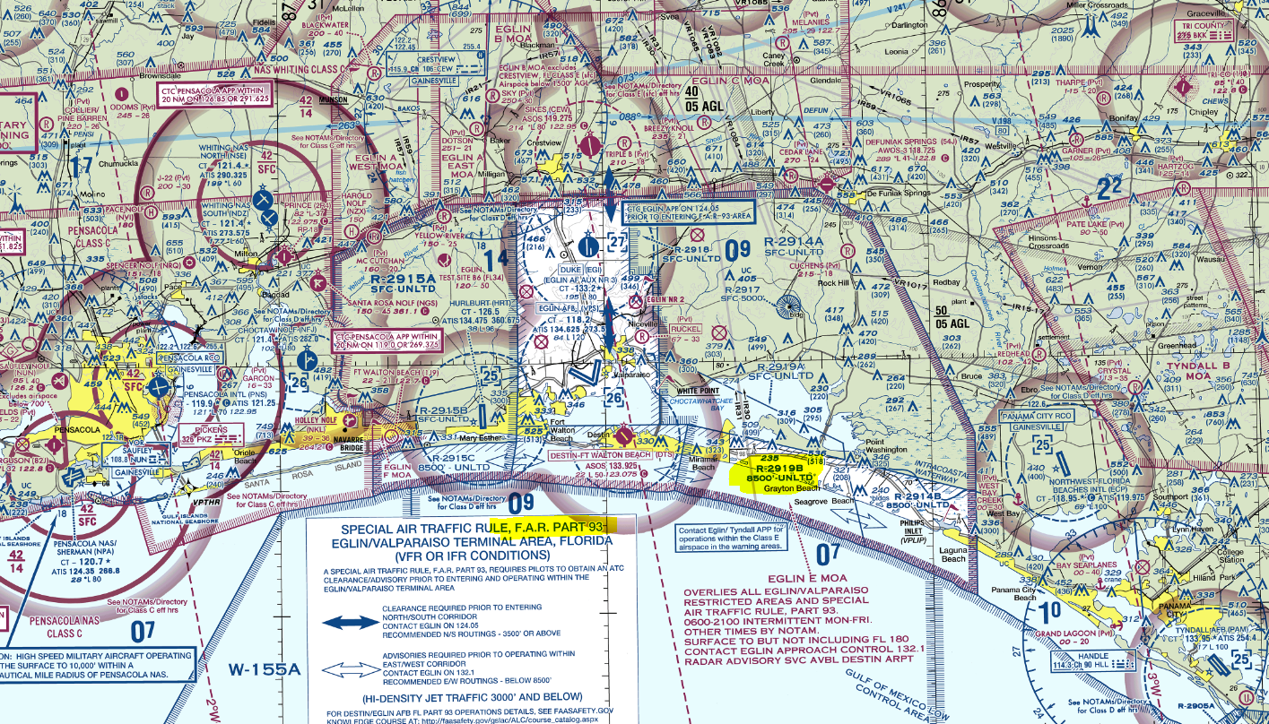
First, let’s start with the Drone, No-Fly. It gets a couple of airports and the property boundaries of Eglin AFB. But, it missed
- The Part 93 airspace (the north-south and east-west corridors through the area that are controlled)
- All of the restricted airspace
- The Destin Airport.
- The relatively new Panama City Airport
- and a boat load of private airports.
So, there’s a lot of airspace you can violate real easy.
AirMap does a much, must better job at capturing the detail of this complicated airspace. However, it too missed a few things such as
- The Part 93 airspace
- A boat load of private airports
- Some of the marked restricted areas do not start at the surface or anywhere near the low altitudes you might be flying at. For example, R-2914B starts at 8500 ft (above the Part 93 airspace).
There are several types of airspace AirMap doesn’t even have a layer for, such as Military Operating Areas, Warning Areas, and Controlled Firing Areas. These areas aren’t no-fly zones, but they are still important for safety reasons. I’m sure the site will improve (hey, it’s still in beta) and I would still endorse its use, but use with caution right now because of the accuracy issues and how timely the website is updated. All FAA maps, airport directories, TFRs and NOTAMs have valid dates to ensure pilots have the most update-to-date information.
The FAA is finally getting into airspace map act this summer with the B4UFLY app. So, the situation is going to get better.